


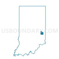
HARRISON 07, Fayette County, Indiana
About
Outline

Summary
| Unique Area Identifier | 577106 |
| Name | HARRISON 07 |
| County | Fayette County |
| State | Indiana |
| Area (square miles) | 6.79 |
| Land Area (square miles) | 6.79 |
| Water Area (square miles) | 0.00 |
| % of Land Area | 99.98 |
| % of Water Area | 0.02 |
| Latitude of the Internal Point | 39.68007440 |
| Longtitude of the Internal Point | -85.14871250 |
Maps


Graphs
Select a template below for downloading or customizing gragh for HARRISON 07, Fayette County, Indiana


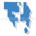


Neighbors
Neighoring Voting District (by Name) Neighboring Voting District on the Map
- CONNERSVILLE 11, Fayette County, IN
- HARRISON 02, Fayette County, IN
- HARRISON 05, Fayette County, IN
- HARRISON 06, Fayette County, IN
- HARRISON 08, Fayette County, IN
- WASHINGTON, Wayne County, IN
- WATERLOO, Fayette County, IN
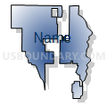
Top 10 Neighboring County Subdivision (by Population) Neighboring County Subdivision on the Map
- Connersville township, Fayette County, IN (12,282)
- Harrison township, Fayette County, IN (6,450)
- Washington township, Wayne County, IN (1,436)
- Waterloo township, Fayette County, IN (607)
Top 10 Neighboring Place (by Population) Neighboring Place on the Map
Top 10 Neighboring Unified School District (by Population) Neighboring Unified School District on the Map
Top 10 Neighboring State Legislative District Lower Chamber (by Population) Neighboring State Legislative District Lower Chamber on the Map
Top 10 Neighboring State Legislative District Upper Chamber (by Population) Neighboring State Legislative District Upper Chamber on the Map
Top 10 Neighboring 111th Congressional District (by Population) Neighboring 111th Congressional District on the Map
Top 10 Neighboring Census Tract (by Population) Neighboring Census Tract on the Map
- Census Tract 107, Wayne County, IN (3,911)
- Census Tract 9540, Fayette County, IN (3,837)
- Census Tract 9542, Fayette County, IN (3,448)
- Census Tract 9541, Fayette County, IN (2,814)
- Census Tract 9543, Fayette County, IN (2,569)